Sold Jan 22, 2014
$128,400
$50,000
by Chong Xac
Mortgage
Sold Sep 29, 2006
$135,500
$108,400
by Argent Mortgage Company Llc
Mortgage Due Oct 01, 2036
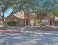
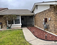
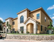
9123 Blockade Drive has been categorized by the local assessors in San Antonio, TX as a residential type of property.
The building on the property was first built in 1986 and is 38 years old.
However, we must point out that the home was most recently renovated and altered in 1992.
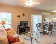
The home has a total of 6 rooms. 4 of these rooms are legally considered as bedrooms.
Residents will have access to 2 full bathrooms.
There are 2 partial bathrooms in the home.
This is a single story building so stairs are not necessary to access other parts of the home.
In addition, 9123 Blockade Drive has 1,572 sqft of living area. The living area typically only takes into consideration the heated or air conditioned part of the building.
The linear feet between the front and back of the lot is 1,050 ft and across the front of the lot is 500 ft.
The area measurement of the land has been determined as 5,249 square feet.
Fans of architecture and design would be interested in knowing that the building on the property was built in a contemporary style.
Want to learn more? We've sourced additional information from the local assessor's office that we've shared on this page with you. For the features and amenities located on the property. There is a attached garage for those who require parking. The garage measured 447 sqft. According to our sources, there are a total of 2 available parking spaces. Residents will have the luxury of enjoying both a unknown and a unknown. Moving on to the building itself. The condition of the building has been evaluated as average. The roof of the building is made of asphalt. The exterior walls of the building are made of a combination of material. The inside of the home is being cooled with central air conditioning at the moment. In terms of heating, it is utilizing a forced air unit. There is a single fireplace in the home. Perfect for those wintery nights. The property was last sold in Jan 15, 2014 for $128,400. That's $63.60 per sqft. Prior to that sales transaction, the property was also sold in Sep 27, 2006 for $135,500. 9123 Blockade Drive was last assessed in 2023. The total value of the property was assessed at $277,130. Specifically, the land the property is located on was valued at $69,460. While improvements on the property were assessed at a total of $207,670. The total market value for this property is the same as the total assessed value as of this moment. The total amount of taxes due from a property owner is $6,365. The initial tax year of delinquency was in 2022. Remember, the purchasing price for your future home is not the costs you'll incur during the purchasing process. That's why it's important to save as much as possible and presumbly above the 20% minimum you may need to put down as down payment. You will want these additional savings to cover closing costs such as attorney fees, homeowner's insurance, title search fees, origination fees, and more. Thankfully, sellers may sometimes offer to cover certain costs as seller concessions to the buyer. Just keep in mind that sellers have their own fees to pay as well. Unfortunately, this property is not currently listed for sale but our inventory of available properties is constantly updating in real time. Check back frequently for updates.
Want to learn more? We've sourced additional information from the local assessor's office that we've shared on this page with you. For the features and amenities located on the property. There is a attached garage for those who require parking. The garage measured 447 sqft. According to our sources, there are a total of 2 available parking spaces. Residents will have the luxury of enjoying both a unknown and a unknown. Moving on to the building itself. The condition of the building has been evaluated as average. The roof of the building is made of asphalt. The exterior walls of the building are made of a combination of material. The inside of the home is being cooled with central air conditioning at the moment. In terms of heating, it is utilizing a forced air unit. There is a single fireplace in the home. Perfect for those wintery nights. The property was last sold in Jan 15, 2014 for $128,400. That's $63.60 per sqft. Prior to that sales transaction, the property was also sold in Sep 27, 2006 for $135,500. 9123 Blockade Drive was last assessed in 2023. The total value of the property was assessed at $277,130. Specifically, the land the property is located on was valued at $69,460. While improvements on the property were assessed at a total of $207,670. The total market value for this property is the same as the total assessed value as of this moment. The total amount of taxes due from a property owner is $6,365. The initial tax year of delinquency was in 2022. Remember, the purchasing price for your future home is not the costs you'll incur during the purchasing process. That's why it's important to save as much as possible and presumbly above the 20% minimum you may need to put down as down payment. You will want these additional savings to cover closing costs such as attorney fees, homeowner's insurance, title search fees, origination fees, and more. Thankfully, sellers may sometimes offer to cover certain costs as seller concessions to the buyer. Just keep in mind that sellers have their own fees to pay as well. Unfortunately, this property is not currently listed for sale but our inventory of available properties is constantly updating in real time. Check back frequently for updates.
This property description is generated based on publicly available data.

9123 Blockade Drive, San Antonio, TX 78240
By proceeding, you consent to receive calls and texts at the number you provided, including marketing by autodialer and prerecorded and artificial voice, and email, from Move, Inc., Move Sales, Inc., Opcity, Inc., realtor.com, and their network of service providers, about your inquiry and other home-related matters, but not as a condition of any purchase. Msg/data rates may apply. This consent applies even if you are on a corporate, state, or national Do Not Call list.
By proceeding, you agree to our Terms of Service.
Building Info
Overview
Building
Neighborhood
Geography
About Northwest Side
Interested in buying or selling?
Find top real estate agents in your area now.
Similar Buildings
Currently no similar buildings aroundNearby Rentals
$1,700 /mo
- 2 Beds
- 1 Bath
$1,699 /mo
- 3 Beds
- 2 Baths
- 1,668 ft²
$1,875 /mo
- 2 Beds
- 3 Baths
- 1,283 ft²
$1,650 /mo
- 2 Beds
- 3 Baths
- 1,098 ft²