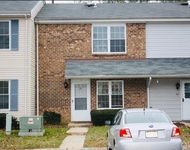
67 Morris Avenue in Spotswood, NJ was first built in 1997 and is 27 years old.
This has been categorized as a residential property type.
67 Morris Avenue has 2,780 sqft of living area. This is typically the area of a building that is heated or air conditioned and does not include the garage, porch or basement square footage.
The linear feet across the front of the lot is 1,100 ft and the linear feet between the front and back of the lot is 1,050.
In total, the area measurement of the land is 11,550 square feet.
Learn more about the property and building on this page. We've gathered and summarized the following transaction history in an effort to provide more transparency and up-to-date information for our users. According to our sources, 67 Morris Avenue sold most recently in Dec 23, 1996 for a total of $67,500. If you work out the math, that's approximately a cost of $24.28 per sqft. There could be many factors that caused the property to sell at a higher price and increase in value. Tax-wise, the current owner is expected to pay close to $12,634 in taxes each year. 67 Morris Avenue was most recently assessed in 2023. During this assessment, the property's total value was estimated to be about $476,400. If we break it down further, the land itself was valued at $176,800. Improvements to the property, however, were assessed at a total of $299,600. The property's total market value has been marked the same as the total assessed value which is pretty typical. Are you already in the process of closing on a property and have signed a purchase agreement? You may want to consider locking in your current mortgage rate if interest rates have been rising or seem volatile. This is what's known in the market as a mortgage rate lock (aka rate protection). However, be sure to evaluate your situation carefully before you do so. There may be certain costs associated with taking this action and you'll want to time the start of your perfectly!Sadly, this property is not available for sale but we are constantly updating our inventory in real time. Sign up for a RealtyHop account and add this property to your favorites to get updates on when this property is back on the market. Or alternatively, you can check back frequently for updates.
Learn more about the property and building on this page. We've gathered and summarized the following transaction history in an effort to provide more transparency and up-to-date information for our users. According to our sources, 67 Morris Avenue sold most recently in Dec 23, 1996 for a total of $67,500. If you work out the math, that's approximately a cost of $24.28 per sqft. There could be many factors that caused the property to sell at a higher price and increase in value. Tax-wise, the current owner is expected to pay close to $12,634 in taxes each year. 67 Morris Avenue was most recently assessed in 2023. During this assessment, the property's total value was estimated to be about $476,400. If we break it down further, the land itself was valued at $176,800. Improvements to the property, however, were assessed at a total of $299,600. The property's total market value has been marked the same as the total assessed value which is pretty typical. Are you already in the process of closing on a property and have signed a purchase agreement? You may want to consider locking in your current mortgage rate if interest rates have been rising or seem volatile. This is what's known in the market as a mortgage rate lock (aka rate protection). However, be sure to evaluate your situation carefully before you do so. There may be certain costs associated with taking this action and you'll want to time the start of your perfectly!Sadly, this property is not available for sale but we are constantly updating our inventory in real time. Sign up for a RealtyHop account and add this property to your favorites to get updates on when this property is back on the market. Or alternatively, you can check back frequently for updates.
This property description is generated based on publicly available data.

67 Morris Avenue, Spotswood, NJ 08884
By proceeding, you consent to receive calls and texts at the number you provided, including marketing by autodialer and prerecorded and artificial voice, and email, from Move, Inc., Move Sales, Inc., Opcity, Inc., realtor.com, and their network of service providers, about your inquiry and other home-related matters, but not as a condition of any purchase. Msg/data rates may apply. This consent applies even if you are on a corporate, state, or national Do Not Call list.
By proceeding, you agree to our Terms of Service.