See Home Value
$225,500
● House - Off Market

5 Blair Dr

Rutland, MA 01543
bedrooms
3 Beds
bathrooms
1 Bath, 1 Half Bath
square feet
1,144 Ft²
$407,890
RealtyHop Estimate
70.03%
Since Jan 1, 2007
National-US
Primary Model

About This Property

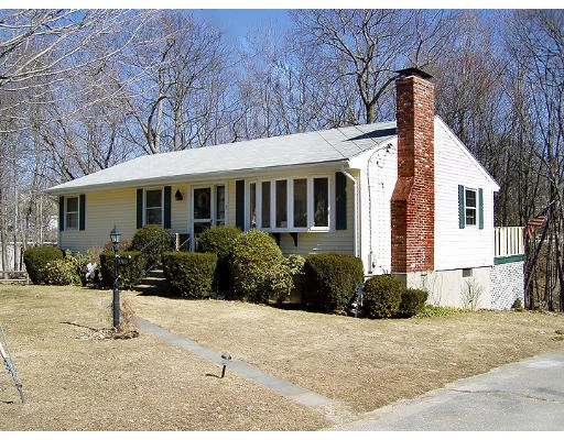
Lovely neighborhood. Close to Holden. Open Kitchen to Living Room. Breakfast bar with work space. Lower level already has a wood stove with fireplace. Enjoy!
Unit Size
1,144 Ft²
Days on Market
-
Land Size
0.34 acres
Price per sqft
$210
Property Type
House
Property Taxes
$179
HOA Dues
-
Year Built
1971

Payment Calculator

Cap Rate Calculator

Last updated: 6 months ago (MLSPIN #70343507)

Price History

Date / Event Date Event Price
Dec 1, 2006 Sold
Sold
Mar 8, 2006 Listed $239,900
Listed
Sep 26, 1997 Sold
Sold
Apr 10, 1997 Listed $106,900
Listed

Property Highlights

Parking Available
Fireplace

Building Info

Overview

    General

  • Year Built: 1971
  • Effective Year Built: 1971
  • Building Count: 1
  • Total Rooms: 6
  • Bedroom Count: 3
  • Bathroom Count: 1
  • Full Bathrooms: 1
  • Partial Bathrooms: 1
  • Building Condition: 6
  • Building Quality: 0
  • Construction Type: 0
  • Building Style: 11
  • Exterior Walls Type: 19
  • Interior Walls Type: 0
  • Roof Shape Type: 1
  • Roof Cover Type: 15
  • Floor Count: 100
  • Living Units: 1
  • Floor Cover: 0
  • Basement Type: 0
  • Basement Area: 0
  • Garage Type: 0
  • Parking Space Count: 0
  • Patio Type: 0
  • Porch Type: 0
  • Pool Type: 0

    Dimensions

  • Lot Size Square Feet: 14,810
  • Total Building Area: 1,144
  • Gross Building Area: 2,468
  • Building Area: 1,144
  • Building Area Measurement: L

    Heating and Cooling

  • Air Conditioning: 0
  • Heating: 1
  • Heated Square Feet: 1,144
  • Heating Fuel Type: 2

    Utilities

  • Sewer System: 0
  • Water Service: 0

Building

  • Building Type: 0
  • Property Class: R
  • Land Acres: 0000000340
  • Standard Land Use Code: 1001
  • County Land Use Code: 101

Neighborhood

  • School District Name: Wachusett School District
  • Census Tract: 721104

Geography

  • Parcel: RUTL M:60-A B:F L:3
  • Block: F
  • Lot: 3
  • Municipality: RUTLAND
  • Latitude: 42.3724
  • Longitude: -71.9325

    Address

  • Full Address: 5 Blair Dr
  • Address - House Number: 5
  • Address - Street Name: Blair
  • Address - Suffix Type: Dr
  • State: MA
  • City Name: Rutland
  • Carrier Code: R005
  • 4-Digit Zip Code: 1765
  • Zip Code: 01543

Valuation

    Tax

  • Tax Year: 2023
  • Tax Amount: $426,800

    Appraisal Valuation

  • Standard Deviation: 0.1893
  • Valuation Date: Jan 17, 2024
  • Confidence Score: 75
  • Final Value: 400,390
  • High Value: 476,214
  • Low Value: 324,566

    Assessments Valuation

  • Assessed Year: 2023
  • Assessed Total Value: $311,100
  • Assessed Land Value: $82,300
  • Assessed Improvements Value: $228,800

    Sales

  • Current Sale Recording Date: Dec 01, 2006
  • Current Sale Price:
  • Current Sale Document Type: 27
  • Current Sale Input Document Number: 00180261
  • Previous Sale Recording Date: Sep 26, 1997
  • Previous Sale Amount: $106,000
  • Previous Sale Document Type: 27
Data used for valuation calculations is provided by RealtyHop, and other third party sources

Comparables

Unit
Status
Type
Beds
Baths
ft²
Price/ft²
Asking Price
Listed On
Closing Price
Sold On
HOA + Taxes

About Rutland


Similar Homes for Sale

Currently no similar homes around

Nearby Rentals


Frequently Asked Questions

When was property at 5 Blair Drive built and last sold?
The property at 5 Blair Drive was built in 1971 and last sold on Jan 1, 1970 for $225,500.
How much is this home worth?
The estimated value of the home located at 5 Blair Drive is $245,745.
What are some comparable homes to 5 Blair Drive?
There are currently no comparable homes to 5 Blair Drive.