See Home Value
$45,000
● Land - Off Market

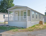
40 SHAMROCK AVE

DOVER, DE 19901
bedrooms
Studio
bathrooms
0 Bath
$49,577
RealtyHop Estimate
10.17%
Since Jan 1, 2022
National-US
Primary Model
Unit Size
-
Days on Market
-
Land Size
0.28 acres
Price per sqft
-
Property Type
Land
Property Taxes
$30
HOA Dues
-
Year Built
1965

Payment Calculator

Cap Rate Calculator

Last updated: 4 years ago (Bright MLS #DEKT2005026)

Price History

Date / Event Date Event Price
Dec 21, 2021 Sold
Sold
Dec 1, 2021 Listed by Keller Williams Realty Central-Delaware $45,000
Listed by Keller Williams Realty Central-Delaware

Property Highlights


Building Info

Overview

    General

  • Year Built: 1965
  • Effective Year Built: 1965
  • Bedroom Count: 0
  • Building Condition: 0
  • Building Quality: 0
  • Construction Type: 0
  • Building Style: 45
  • Exterior Walls Type: 0
  • Interior Walls Type: 0
  • Roof Shape Type: 0
  • Roof Cover Type: 0
  • Floor Cover: 0
  • Basement Type: 0
  • Basement Area: 0
  • Garage Type: 4
  • Garage Square Area: 540
  • Parking Space Count: 2
  • Patio Type: 0
  • Porch Type: 0
  • Pool Type: 0
  • Location Influence Type: 19

    Dimensions

  • Lot Size Square Feet: 12,197
  • Lot Size Depth Feet: 1,250
  • Lot Size Frontage Feet: 1,000
  • Total Building Area: 720
  • Building Area: 720
  • Building Area Measurement: L

    Heating and Cooling

  • Air Conditioning: 0
  • Heating: 0
  • Heated Square Feet: 720
  • Heating Fuel Type: 0

    Utilities

  • Sewer System: 5
  • Water Service: 5

Building

  • Building Type: 0
  • Property Class: R
  • Subdivision: CARTER DEVELOPMENT
  • Land Acres: 0000000280
  • Standard Land Use Code: 1006
  • County Land Use Code: P
  • Mobile Home Indicator: T
  • Legal Description 1: NR. CAMDEN, LOTS 68 & 69, 12,202 SQ. FT. PLOT OF A.B. CARTER

Neighborhood

  • School District Name: Caesar Rodney School District
  • School Tax School District: 20
  • School Tax District Code 2: 41
  • School Tax District Code 3: 04
  • Census Tract: 041600

Zoning

  • Zoning: MULTI

Geography

  • Assessors Map Reference: MB 3 PG 34
  • Account Number: 39592
  • District: 00
  • Parcel: 7-00-094.08-02-55.00-000
  • Lot: 68-69
  • Municipality: UNINCORPORATED
  • Latitude: 39.1184
  • Longitude: -75.5338

    Address

  • Full Address: 40 Shamrock Ave
  • Address - House Number: 40
  • Address - Street Name: Shamrock
  • Address - Suffix Type: Ave
  • State: DE
  • City Name: Dover
  • Carrier Code: C015
  • 4-Digit Zip Code: 5529
  • Zip Code: 19901

Valuation

    Tax

  • Tax Year: 2023
  • Tax Amount: $27,546

    Appraisal Valuation

  • Standard Deviation: 0.2434
  • Valuation Date: Sep 27, 2023
  • Confidence Score: 65
  • Final Value: 136,363
  • High Value: 169,562
  • Low Value: 103,165

    Assessments Valuation

  • Assessed Year: 2023
  • Assessed Total Value: $10,900
  • Assessed Land Value: $6,700
  • Assessed Improvements Value: $4,200

    Sales

  • Current Sale Contract Date: Dec 20, 2021
  • Current Sale Recording Date: Dec 21, 2021
  • Current Sale Price:
  • Current Sale Document Type: 27
  • Current Sale Input Document Number: 2021-439496
Data used for valuation calculations is provided by RealtyHop, and other third party sources

Comparables

Unit
Status
Type
Beds
Baths
ft²
Price/ft²
Asking Price
Listed On
Closing Price
Sold On
HOA + Taxes

About Highland Acres South


Similar Homes for Sale

Currently no similar homes around

Nearby Rentals

Unit for rent at 1679 S State Street, DOVER, DE, 19901

$1,200 /mo

  • 1 Bed
  • 1 Bath
  • 832 ft²
1679 S State Street #A35, DOVER, DE, 19901 Listing by Brittany Marie Breeding


Frequently Asked Questions

When was property at 40 Shamrock Avenue built and last sold?
The property at 40 Shamrock Avenue was built in 1965 and last sold on Dec 20, 2021 for $45,000.
How much is this home worth?
The estimated value of the home located at 40 Shamrock Avenue is $45,450.
What are some comparable homes to 40 Shamrock Avenue?
There are currently no comparable homes to 40 Shamrock Avenue.

Neighborhoods
Nearby Counties