


$448,897*
●
Commercial -
Off Market
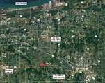
242 N 600 W
Valparaiso, IN 46385
Studio
0 Bath
466527 Sqft
$387,000 - $471,000
Reference Base Price*
4.64%
Since Nov 1, 2022
National-US
Primary Model
Sold Apr 22, 2005
$218,800
Buyer
About This Property
GREAT CORNER LOT OPPORTUNITY ON US 30 - [10.71 ACRES] - PRICED TO
SELL!IMAGINE THE POSSIBILITIES - 661 FT of FRONTAGE ON US-30 and
704 FT DEEP!
The manager has listed the unit size as 466527 square feet.
The manager has listed the unit size as 466527 square feet.
Unit Size
466,527Ft²
Days on Market
-
Land Size
10.71 acres
Price per sqft
$1
Property Type
Commercial
Property Taxes
-
HOA Dues
-
Year Built
1936
Price History
| Date / Event | Date | Event | Price |
|---|---|---|---|
| Oct 7, 2022 | No longer available | - | |
| No longer available | |||
| Aug 10, 2022 | Listed | $429,000 | |
| Listed | |||
Property Highlights
Building Info
Overview
Building
Neighborhood
Geography

242 N 600 W
By proceeding, you consent to receive calls and texts at the number you provided, including marketing by autodialer and prerecorded and artificial voice, and email, from Move, Inc., Move Sales, Inc., Opcity, Inc., realtor.com, and their network of service providers, about your inquiry and other home-related matters, but not as a condition of any purchase. Msg/data rates may apply. This consent applies even if you are on a corporate, state, or national Do Not Call list.
By proceeding, you agree to our Terms of Service.