Sold Aug 01, 2012
$81,000
Buyer
Seller
Sold Jun 26, 2009
$365,000
Buyer
Seller
$565,000
by Provident Bank
Mortgage
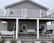
31-33 Ashworth Avenue has been categorized by the local assessors in Hampton, NH as a residential type of property.
The building on the property was first built in 1920 and is 104 years old.
The building has a total of 2 stories.
In addition, 31-33 Ashworth Avenue has 1,916 sqft of living area. The living area typically only takes into consideration the heated or air conditioned part of the building.
The area measurement of the land has been determined as 4,356 square feet.
Want to learn more? We've sourced additional information from the local assessor's office that we've shared on this page with you. Moving on to the building itself. The condition of the building has been evaluated as average. The building has a gable style roof made of asphalt. The exterior walls of the building are made of alum/vinyl siding. In terms of heating, it is utilizing baseboard heaters and being fueled with electricity. We've gathered and summarized the following transaction history in an effort to provide more transparency and up-to-date information for our users. According to our sources, 31-33 Ashworth Avenue sold most recently in Jan 1, 1970 for a total of $81,000. If you work out the math, that's approximately a cost of $42.28 per sqft. Before that, the property was also sold for $365,000 in Jan 1, 1970. There could be many factors that caused the property to sell at a lower price and decrease in value. Tax-wise, the current owner is expected to pay close to $7,955 in taxes each year. 31-33 Ashworth Avenue was most recently assessed in 2023. During this assessment, the property's total value was estimated to be about $474,900. If we break it down further, the land itself was valued at $301,900. Improvements to the property, however, were assessed at a total of $173,000. The property's total assessed value has been marked as more than the total market value which is pretty atypical. If you're currently on the market shopping for a loan, then you've most likely encountered the two terms "interest rate" and "annual percentage rate (aka APR)". But do you know the difference between the two? Typically, APRS are higher than interest rates because they include most additional fees and one-time costs. As a result, it's important to look at both and if you notice that your APR is significantly higher, that might mean that too many additional fees are being charged. Sadly, this property is not available for sale but we are constantly updating our inventory in real time. Sign up for a RealtyHop account and add this property to your favorites to get updates on when this property is back on the market. Or alternatively, you can check back frequently for updates.
Want to learn more? We've sourced additional information from the local assessor's office that we've shared on this page with you. Moving on to the building itself. The condition of the building has been evaluated as average. The building has a gable style roof made of asphalt. The exterior walls of the building are made of alum/vinyl siding. In terms of heating, it is utilizing baseboard heaters and being fueled with electricity. We've gathered and summarized the following transaction history in an effort to provide more transparency and up-to-date information for our users. According to our sources, 31-33 Ashworth Avenue sold most recently in Jan 1, 1970 for a total of $81,000. If you work out the math, that's approximately a cost of $42.28 per sqft. Before that, the property was also sold for $365,000 in Jan 1, 1970. There could be many factors that caused the property to sell at a lower price and decrease in value. Tax-wise, the current owner is expected to pay close to $7,955 in taxes each year. 31-33 Ashworth Avenue was most recently assessed in 2023. During this assessment, the property's total value was estimated to be about $474,900. If we break it down further, the land itself was valued at $301,900. Improvements to the property, however, were assessed at a total of $173,000. The property's total assessed value has been marked as more than the total market value which is pretty atypical. If you're currently on the market shopping for a loan, then you've most likely encountered the two terms "interest rate" and "annual percentage rate (aka APR)". But do you know the difference between the two? Typically, APRS are higher than interest rates because they include most additional fees and one-time costs. As a result, it's important to look at both and if you notice that your APR is significantly higher, that might mean that too many additional fees are being charged. Sadly, this property is not available for sale but we are constantly updating our inventory in real time. Sign up for a RealtyHop account and add this property to your favorites to get updates on when this property is back on the market. Or alternatively, you can check back frequently for updates.
This property description is generated based on publicly available data.

31-33 Ashworth Avenue, Hampton, NH 03842
By proceeding, you consent to receive calls and texts at the number you provided, including marketing by autodialer and prerecorded and artificial voice, and email, from Move, Inc., Move Sales, Inc., Opcity, Inc., realtor.com, and their network of service providers, about your inquiry and other home-related matters, but not as a condition of any purchase. Msg/data rates may apply. This consent applies even if you are on a corporate, state, or national Do Not Call list.
By proceeding, you agree to our Terms of Service.