


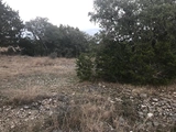
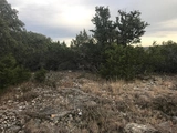


192 Kamira Drive has been categorized by the local assessors in Kerrville, TX as a agricultural type of property.
The area measurement of the land has been determined as 239,580 square feet.
Want to learn more? We've sourced additional information from the local assessor's office that we've shared on this page with you. 192 Kamira Drive was last assessed in 2021. The total value of the property was assessed at $31,662. Specifically, the land the property is located on was valued at $31,662. The total market value for this property is the same as the total assessed value as of this moment. The total amount of taxes due from a property owner is $485. If you're currently on the market shopping for a loan, then you've most likely encountered the two terms "interest rate" and "annual percentage rate (aka APR)". But do you know the difference between the two? Typically, APRS are higher than interest rates because they include most additional fees and one-time costs. As a result, it's important to look at both and if you notice that your APR is significantly higher, that might mean that too many additional fees are being charged. Unfortunately, this property is not currently listed for sale but our inventory of available properties is constantly updating in real time. Check back frequently for updates.
Want to learn more? We've sourced additional information from the local assessor's office that we've shared on this page with you. 192 Kamira Drive was last assessed in 2021. The total value of the property was assessed at $31,662. Specifically, the land the property is located on was valued at $31,662. The total market value for this property is the same as the total assessed value as of this moment. The total amount of taxes due from a property owner is $485. If you're currently on the market shopping for a loan, then you've most likely encountered the two terms "interest rate" and "annual percentage rate (aka APR)". But do you know the difference between the two? Typically, APRS are higher than interest rates because they include most additional fees and one-time costs. As a result, it's important to look at both and if you notice that your APR is significantly higher, that might mean that too many additional fees are being charged. Unfortunately, this property is not currently listed for sale but our inventory of available properties is constantly updating in real time. Check back frequently for updates.
This property description is generated based on publicly available data.

192 Kamira Drive, Kerrville, TX 78028
By proceeding, you consent to receive calls and texts at the number you provided, including marketing by autodialer and prerecorded and artificial voice, and email, from Move, Inc., Move Sales, Inc., Opcity, Inc., realtor.com, and their network of service providers, about your inquiry and other home-related matters, but not as a condition of any purchase. Msg/data rates may apply. This consent applies even if you are on a corporate, state, or national Do Not Call list.
By proceeding, you agree to our Terms of Service.
0 Past Sales
| Date | Unit | Beds | Baths | Sqft | Price | Closed | Owner | Listed By |
|---|