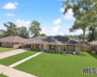
11810 North Milstead Place
11810 North Milstead Place, Baton Rouge, LA 70818
Property
in
Brownsfield-Central
Sold Aug 11, 2000
$147,000
$1,000,000
by Hancock Whitney Bank
Mortgage Due Feb 24, 2052
Local assessors in Baton Rouge, LA have categorized 11810 North Milstead Place as a residential type of property.
The home was built in 1995 and is 29 years old.
The property's lot size has been calculated to be 43,560 square feet.
If we look only at the heated or air conditioned part of the building, then 11810 North Milstead Place has a total of 2,028 sqft of living area.
Note that this number does not include the square footage of the garage, basement, and/or porch into its calculations.
Curious to learn more about the home? Our team of data engineers have sourced the most up-to-date information from the local assessors office to share with you. Moving onto specific details regarding the building. Our sources show that the building condition is good. We've gathered and summarized the following transaction history in an effort to provide more transparency and up-to-date information for our users. According to our sources, 11810 North Milstead Place sold most recently in Aug 11, 2000 for a total of $147,000. If you work out the math, that's approximately a cost of $72.49 per sqft. There could be many factors that caused the property to sell at a higher price and increase in value. Tax-wise, the current owner is expected to pay close to $2,117 in taxes each year. 11810 North Milstead Place was most recently assessed in 2023. During this assessment, the property's total value was estimated to be about $23,320. If we break it down further, the land itself was valued at $2,200. Improvements to the property, however, were assessed at a total of $21,120. Homeowners who care about taxes, will be happy to see that the property's total assessed value has been marked as less than the total market value. As you can see, there are a lot of things to consider when purchasing a home. For example, have you evaluated your own Debt-To-Income ratio (DTI) and understood how this may impact the number of loan options you have access to? Don't worry, we'll cover the basics such as what a DTI ratio is, how to calculate yours, what most lenders consider to be an ideal ratio, and also provide our tips on how you can improve your score if it is on the higher side.Sadly, this property is not available for sale but we are constantly updating our inventory in real time. Sign up for a RealtyHop account and add this property to your favorites to get updates on when this property is back on the market. Or alternatively, you can check back frequently for updates.
Curious to learn more about the home? Our team of data engineers have sourced the most up-to-date information from the local assessors office to share with you. Moving onto specific details regarding the building. Our sources show that the building condition is good. We've gathered and summarized the following transaction history in an effort to provide more transparency and up-to-date information for our users. According to our sources, 11810 North Milstead Place sold most recently in Aug 11, 2000 for a total of $147,000. If you work out the math, that's approximately a cost of $72.49 per sqft. There could be many factors that caused the property to sell at a higher price and increase in value. Tax-wise, the current owner is expected to pay close to $2,117 in taxes each year. 11810 North Milstead Place was most recently assessed in 2023. During this assessment, the property's total value was estimated to be about $23,320. If we break it down further, the land itself was valued at $2,200. Improvements to the property, however, were assessed at a total of $21,120. Homeowners who care about taxes, will be happy to see that the property's total assessed value has been marked as less than the total market value. As you can see, there are a lot of things to consider when purchasing a home. For example, have you evaluated your own Debt-To-Income ratio (DTI) and understood how this may impact the number of loan options you have access to? Don't worry, we'll cover the basics such as what a DTI ratio is, how to calculate yours, what most lenders consider to be an ideal ratio, and also provide our tips on how you can improve your score if it is on the higher side.Sadly, this property is not available for sale but we are constantly updating our inventory in real time. Sign up for a RealtyHop account and add this property to your favorites to get updates on when this property is back on the market. Or alternatively, you can check back frequently for updates.
This property description is generated based on publicly available data.

11810 North Milstead Place, Baton Rouge, LA 70818
By proceeding, you consent to receive calls and texts at the number you provided, including marketing by autodialer and prerecorded and artificial voice, and email, from Move, Inc., Move Sales, Inc., Opcity, Inc., realtor.com, and their network of service providers, about your inquiry and other home-related matters, but not as a condition of any purchase. Msg/data rates may apply. This consent applies even if you are on a corporate, state, or national Do Not Call list. By proceeding, you agree to our Terms of Service.