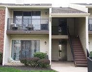
Local assessors in Basking Ridge, NJ have categorized 11 Governor Drive as a residential type of property.
The home was built in 1994 and is 30 years old.
The property's lot size has been calculated to be 25,700 square feet.
Sharp-eyed aficionados of architecture will notice that the home on the property was built in a colonial style.
This is a 2 story home so residents will need to have climb at least one set of stairs on a daily basis.
If we look only at the heated or air conditioned part of the building, then 11 Governor Drive has a total of 3,833 sqft of living area.
Note that this number does not include the square footage of the garage, basement, and/or porch into its calculations.
Curious to learn more about the home? Our team of data engineers have sourced the most up-to-date information from the local assessors office to share with you. Additional features on the property are as follows. There is a attached garage for those who need a place to park their vehicle. There are 3 available parking spaces so it's a great situation for those with more than one car. It might sound scary but did you know that buildings can move depending on the weather? Both hot and cold weather can have severe impact on the longevity of your home structure depending on how much your home moves. Hence why architects pay a lot of attention to the type of control joints used in the construction process. Just so you know, this home was built with frame control joints. The property was last sold in Jun 28, 1994 for $450,111. That's $117.43 per sqft. 11 Governor Drive was last assessed in 2023. The total value of the property was assessed at $1,099,500. Specifically, the land the property is located on was valued at $384,800. While improvements on the property were assessed at a total of $714,700. The total assessed value for this property is more than the total market value as of this moment. Which is pretty atypical. The total amount of taxes due from a property owner is $20,737. If you're currently on the market shopping for a loan, then you've most likely encountered the two terms "interest rate" and "annual percentage rate (aka APR)". But do you know the difference between the two? Typically, APRS are higher than interest rates because they include most additional fees and one-time costs. As a result, it's important to look at both and if you notice that your APR is significantly higher, that might mean that too many additional fees are being charged. Unfortunately, this property is not currently listed for sale but our inventory of available properties is constantly updating in real time. Check back frequently for updates.
Curious to learn more about the home? Our team of data engineers have sourced the most up-to-date information from the local assessors office to share with you. Additional features on the property are as follows. There is a attached garage for those who need a place to park their vehicle. There are 3 available parking spaces so it's a great situation for those with more than one car. It might sound scary but did you know that buildings can move depending on the weather? Both hot and cold weather can have severe impact on the longevity of your home structure depending on how much your home moves. Hence why architects pay a lot of attention to the type of control joints used in the construction process. Just so you know, this home was built with frame control joints. The property was last sold in Jun 28, 1994 for $450,111. That's $117.43 per sqft. 11 Governor Drive was last assessed in 2023. The total value of the property was assessed at $1,099,500. Specifically, the land the property is located on was valued at $384,800. While improvements on the property were assessed at a total of $714,700. The total assessed value for this property is more than the total market value as of this moment. Which is pretty atypical. The total amount of taxes due from a property owner is $20,737. If you're currently on the market shopping for a loan, then you've most likely encountered the two terms "interest rate" and "annual percentage rate (aka APR)". But do you know the difference between the two? Typically, APRS are higher than interest rates because they include most additional fees and one-time costs. As a result, it's important to look at both and if you notice that your APR is significantly higher, that might mean that too many additional fees are being charged. Unfortunately, this property is not currently listed for sale but our inventory of available properties is constantly updating in real time. Check back frequently for updates.
This property description is generated based on publicly available data.

11 Governor Drive, Basking Ridge, NJ 07920
By proceeding, you consent to receive calls and texts at the number you provided, including marketing by autodialer and prerecorded and artificial voice, and email, from Move, Inc., Move Sales, Inc., Opcity, Inc., realtor.com, and their network of service providers, about your inquiry and other home-related matters, but not as a condition of any purchase. Msg/data rates may apply. This consent applies even if you are on a corporate, state, or national Do Not Call list.
By proceeding, you agree to our Terms of Service.